Viogor-Zanik (Bosnia and Herzegovina)
Ownership
100% (Drina Resources d.o.o. Srebrenica)
Area
168 km2
District
Srebrenica igneous complex (Podrinje metallogenic zone)
Deposit type
Porphyry-style, skarn-type, IS epithermal
Commodities
Cu, Pb, Zn, Au, Ag, Sb, Sn
Status
Phase II drill campaign (Q2 2023)
About Viogor-Zanik Project
The Srebrenica Magmatic Complex is the 30-million-year-old, western member of the Podrinje Metallogenic District which includes the Serbian Cer and Boranja mining districts, collectively the northwesternmost extensions of the Serbo-Macedonian Metallogenic Province (SMMP) of the Western Tethyan Metallogenic Belt. The SMMP mainly hosts ore deposits of Paleogene to Neogene age. The Srebrenica district is hosted by Oligo-Miocene, intermediate to mafic subvolcanic rocks emplaced into Paleozoic slates and covered by Neogene felsic pyroclastics.
The district has been known to host two types of mineralization: (i) cassiterite-bearing, greisen mineralization related to quartz-tourmaline-muscovite facies, and (ii) Pb–Zn–Fe bearing hydrothermal veins with variable concentrations of Ag, Sn and Sb. As such, the Srebrenica district shares many mineralogical similarities to those of the Andean Ag–Sn belt, Germany’s Freiberg-Erzgebirge district, the Lavrion deposit in Greece, and the Baia Mare Metallogenic District of East Carpathians, in Romania. The Srebrenica mineralization contains a comparable mineral assemblage to that of the San José Ag–Sn deposit, Oruro, Bolivia (cassiterite, stannite, pyrite, chalcopyrite, argentian tetrahedrite, galena and sphalerite).
The ore mineralization in Srebrenica is related to a syn-volcanic ring-radial fractures where hydrothermal ore veins are concentrated within four main systems of brecciated fractures: (i) the NE ore zone (Sase/Gross mine), (ii) the NW ore zone (Čumavići), (iii) the northern ore zone (Vitlovac), and (iv) the central ore system (Guber, Olovine). The origin of ore mineralization is genetically associated with a concealed plutonic body of S-type granitoid composition shallowly emplaced beneath the south-central part of the district.
Extensive greisen bodies are particularly well developed and composed of quartz, tourmaline and muscovite are found along the contact between the micro-granodiorites and Paleozoic slates. Tourmaline occurs as needle shaped, columnar and radiating aggregates. Greisen tend to be associated with endoskarns and indicate a proximal intrusive body with upper aureoles sealed shut to prevent fluids escaping. The Pb-Zn sulfides, accompanied by siderite, marcasite, sulfosalts and Ag sulfides are the dominant hydrothermal ore minerals, developed in the central part of the district, while in the peripheral parts there is mineralization associated with low-temperature epithermal veins (Sb, locally W, and Hg).
Location map
Technical Report
Phase II Drilling Program

The Srebrenica Magmatic Complex
3-license, 168 km2 land package surrounds Mineco Ltd.’s Sase Mine with a total probable and proven ore reserve of 6.19 Mt at 4.84% Pb, 5.82% Zn, 78.56 g/t Ag and 318.73 g/t Cd. Exploration success by Terra Balcanica’s maiden drilling program proves the complex is both well endowed and underexplored.
(For full disclosure of stated mineral grades and reserves see Appendix III of the corporate presentation).
Geological map of the Viogor-Zanik exploration project
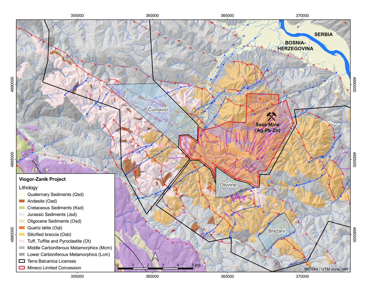
Čumavići target
- Shallow, high grade, intermediate sulphidation epithermal Ag-Au-Pb-Zn-Sb vein system;
- A 7.2 km, NW-SE structural corridor hosting altered zones of volcanics with occurrences of Pb, Zn and Fe sulfides comprising:
- Čumavići Ridge zone – NW vein system
- Josheva zone – SE vein system
- Ćumurnica zone – sub-parallel SW vein system
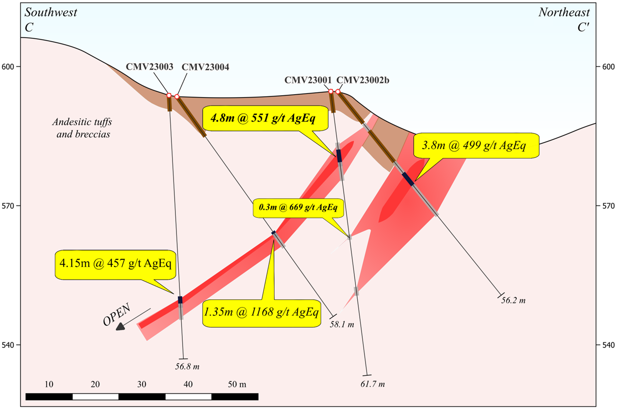
Drillhole section for 2023 drillholes at the Cumavici Ridge Target. Section is located 82 m SE of 2022 drillholes CMVDD004 and CMVDD005
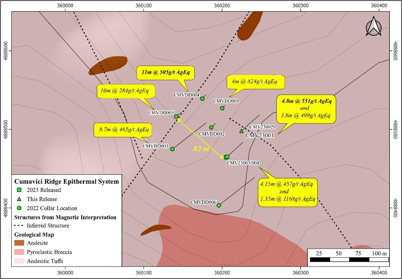
Geological map illustrating the drillholes at the Cumavici Ridge locality. AgEq values are labelled for selected 2022 and 2023 drill intercepts (See Company’s new releases dated 13 November 2023, 27 February 2023, 17 January 2024). Current drilling efforts confirm mineralization over 82 m NW/SE strike length. (WGS84/UTM Zone 34N)

A northwest oriented cross section of the Cumavici Ridge location depicting the drillholes CMVDD001 through CMVDD003 with polymetallic intervals labelled as AgEq. Sulphide-bearing, vein-hosted mineralization is open down-dip to the southwest. (see Company news release from October 22nd, 2022)
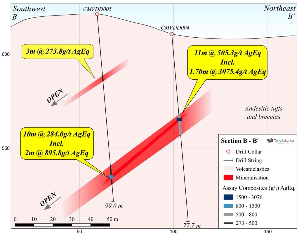
Section displaying assay results from Cumavici Ridge diamond drillholes CMVDD004 and 005. Mineralization intervals up to 3075.4 g/t AgEq over 1.7 m. CMVDD004 represents the highest grade results to date and is open to the NW and down-dip SW. (See Company news release from February 27th, 2023).
Drillhole | From (m) | To (m) | Length (m) | Ag (g/t) | Au (g/t) | Pb (%) | Sb (%) | Zn (%) | AgEq* (g/t) |
|---|---|---|---|---|---|---|---|---|---|
CMVDD001 | 29.0 | 33.0 | 4.0 | 131.5 | 0.84 | 2.12 | 1.85 | 4.59 | 824.2 |
including | 30.0 | 32.0 | 2.0 | 261 | 1.62 | 4.20 | 3.70 | 9.10 | 1634.4 |
CMVDD002 | 45.0 | 47.0 | 2.0 | 144 | 0.23 | 4.27 | 0.44 | 8.26 | 816.1 |
CMVDD003 | 89.0 | 97.7 | 8.7 | 105 | 0.81 | 0.70 | 1.20 | 1.17 | 465.5 |
including | 91.0 | 93.0 | 2.0 | 289 | 1.16 | 2.03 | 3.50 | 3.16 | 1196.6 |
CMVDD004 | 43.0 | 54.0 | 11.0 | 225 | 0.30 | 0.56 | 1.48 | 0.83 | 505.3 |
including | 44.8 | 46.5 | 1.7 | 1420 | 0.81 | 3.42 | 9.40 | 4.95 | 3075.4 |
CMVDD005 | 33.0 | 36.0 | 3.0 | 39 | 0.21 | 0.05 | 1.44 | 0.27 | 273.8 |
including | 81.0 | 91.0 | 10.0 | 75 | 0.78 | 0.40 | 0.68 | 0.61 | 284.0 |
including | 86.0 | 88.0 | 2.0 | 258 | 2.85 | 1.42 | 1.70 | 1.89 | 895.8 |
For full disclosure see Company’s news release dated September 8th October 22nd, 2022, February 2nd and 27th 2023.
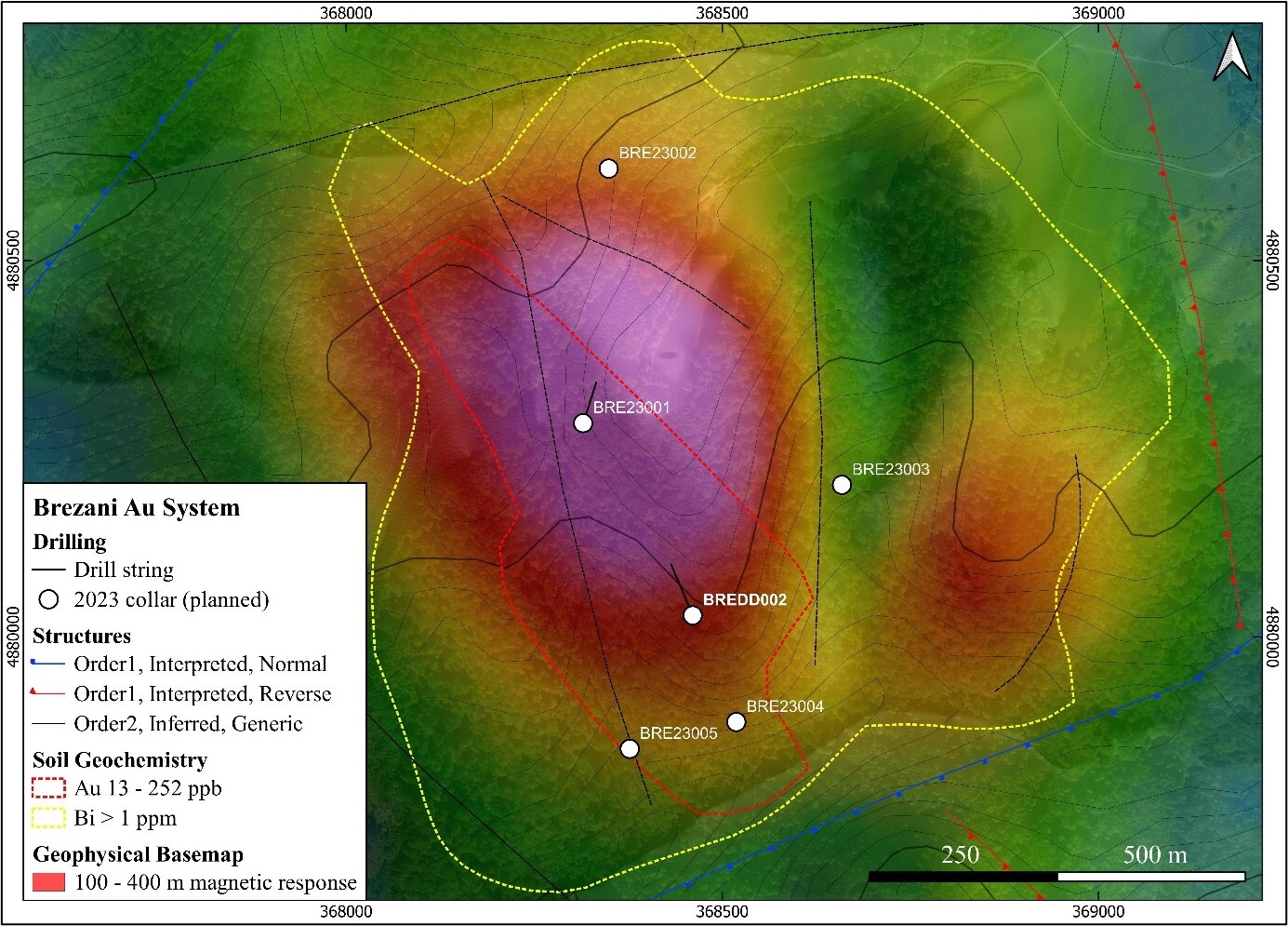
Brežani Discovery
- 0.61 g/t AuEq over 88.0 m from surface in maiden diamond drillhole
- Au mineralised chlorite-sericite altered diorites, hydrothermal breccias, retrograde skarn, calc-silicate hornfels
- Intermediate sulphidation Au-Ag-As-Bi-Pb-Zn veining
- 1.2 km diameter magnetic high anomaly, coincident with high conductivity below a gold skarn
- >850 m strike length Au-Bi-Te-Zn soil anomaly
- 0.54 g/t AuEq over 32 m in surface trenching (See Company news release dated 17th August 2022)
- 2023 drilling efforts extended BREDD002 to 674 m depth alongside 4 shallow holes BRE23001-004 which averaged 136 m depth. Assay results pending!
Drillhole | From (m) | To (m) | Length (m) | Au (g/t) | Ag (g/t) | Cu (%) | Zn (%) | AuEq* (g/t) |
|---|---|---|---|---|---|---|---|---|
BREDD001 | 0.0 | 28.6 | 28.6 | 0.53 | 0.32 | 0.03 | 0.06 | 0.58 |
including | 20.1 | 25.8 | 5.7 | 1.24 | 0.33 | 0.03 | 0.10 | 1.27 |
BREDD002 | 0.0 | 88.0 | 88.0 | 0.50 | 0.37 | 0.03 | 0.19 | 0.61 |
including | 10.3 | 16.5 | 6.2 | 1.01 | 0.22 | 0.03 | 0.04 | 1.01 |
including | 32.0 | 38.0 | 6.0 | 1.50 | 1.18 | 0.07 | 0.72 | 1.90 |
including | 45.0 | 53.0 | 8.0 | 0.77 | 1.32 | 0.11 | 0.75 | 1.27 |
For full disclosure see Company’s news release dated January 24th, 2023
Drillhole | From (m) | To (m) | Length (m) | Ag (g/t) | Au (g/t) | Pb (%) | Sb (%) | Zn (%) | AuEq* (g/t) |
|---|---|---|---|---|---|---|---|---|---|
BREDD002 | 482.1 | 501.7 | 19.6 | 84.6 | 0.18 | 0.20 | 0.79 | 0.48 | 436 |
including | 482.1 | 491.9 | 9.8 | 129.3 | 0.26 | 0.24 | 1.42 | 0.70 | 746 |
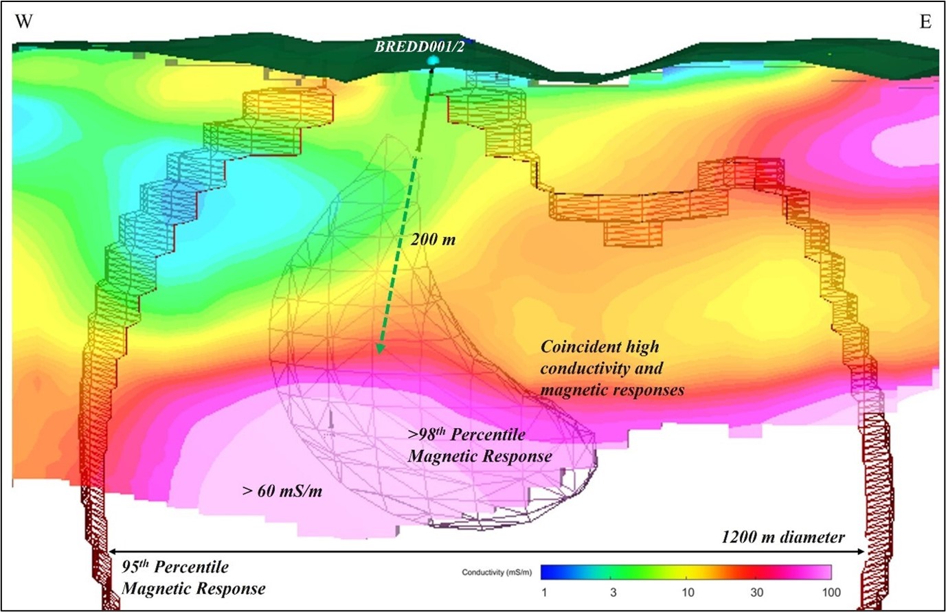
Conductivity profile of the Brezani target with >95th percentile magnetic anomaly. BREDD002 tests the resistive volume above an abrupt change into coincident high magnetic and elevated electrical conductivity response below 300 m depth which culminates at >60 mS/m at approximately 450 m of depth. Dashed line represents distance from the end of BREDD002 to the top of conductive anomaly which remains untested.
Project Milestones
2023 – Phase II Drilling Program
- Extend Cumavici mineralisation NW/SE and prove down-dip continuation
- Unlock the potential of the Brezani gold system – testing a porphyry model
2022 Maiden Drilling Program
- Discovery of a shallow, polymetallic epithermal system at Cumavici Ridge
- Significant high grade intercepts near surface
- Discovery of a gold system at Brezani
- Largely untested with considerable exploration upside for porphyry style mineralisation
2021/2022 Target generation using data from ca. C$1,800,000 privately funded exploration activities:
- Lithological and alteration mapping, stream and litho-geochemical sampling (rock chip)
- ASTER, SENTINEL-2 & LANDSAT-8 remote sensing to identify favourable clay mineralogy
- Successful inversion of historical gravity and magnetic data
- A 1,331-line km airborne magnetic ± EM survey completed
- A 1,650 sample 250 x 250 m grid soil survey (125×125 m infills)
- Project scale gamma ray spectrometry
- Project scale structural mapping
- A detailed 1:2,500 scale mapping of key areas of interest with targeted rock chip sampling
- Data synthesis and target definition
Drill targets have been identified through analysis of the various geological data layers.
These have been ground-verified and ranked by empirical targeting where appropriate (weights of evidence)
2021-2022 TARGET GENERATION (click to view)
Soil Survey Target Zones
1,650 soil samples taken on a 250 x 250m grid over 133 km2 with 125 m-infill surveys over key anomalies.
Path-finder elements confirm a zoned mineralized system with a proximal, high-temp. elemental association indicative of porphyry deposits transitioning to an epithermal system NW.
Cu+Sn (higher-T proximal porphyry association)
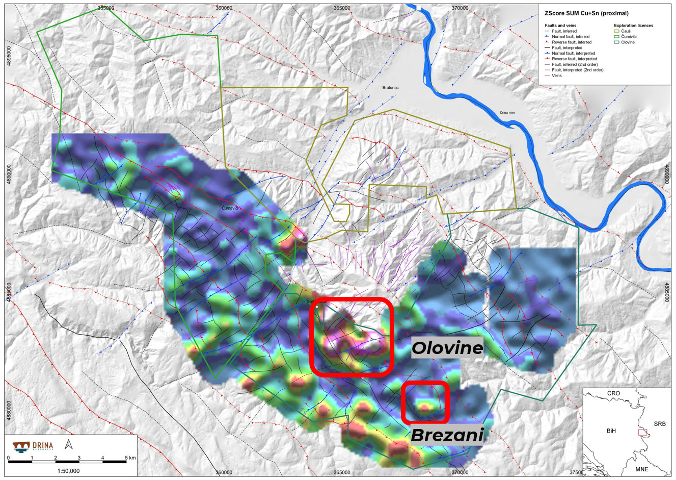
Cu+Sn Zscore SUM for soil geochemistry with elevated responses indicating areas proximal to a magmatic-hydrothermal center.
Te+Bi (higher-T proximal porphyry association)
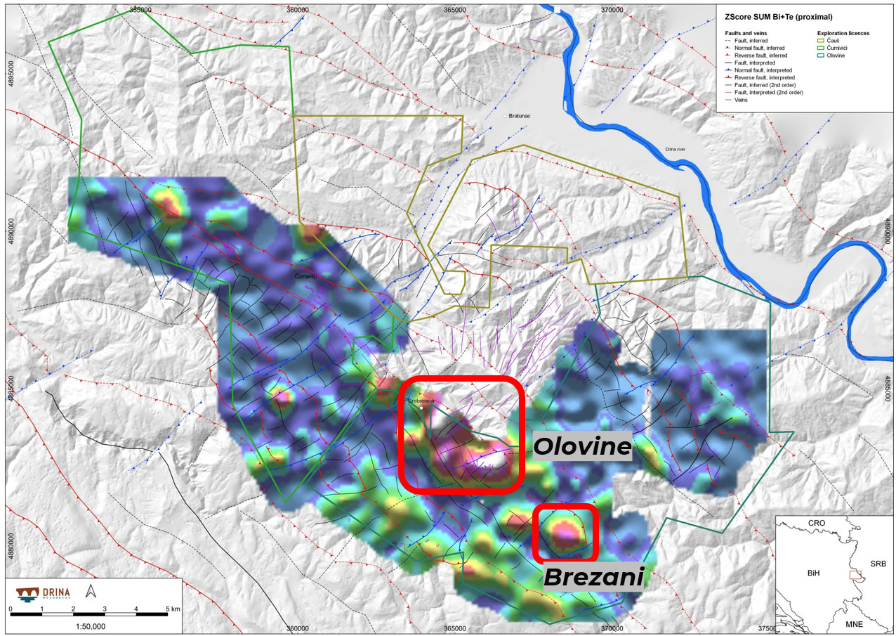
Bi+Te Zscore SUM for soil geochemistry with elevated responses indicating areas proximal to a magmatic-hydrothermal center. Elevated Bi also maps the extent of phyllic alteration due to its compatibility in sulphides such as pyrite.
Mn+Zn ( distal porphyry/shallow epithermal association )
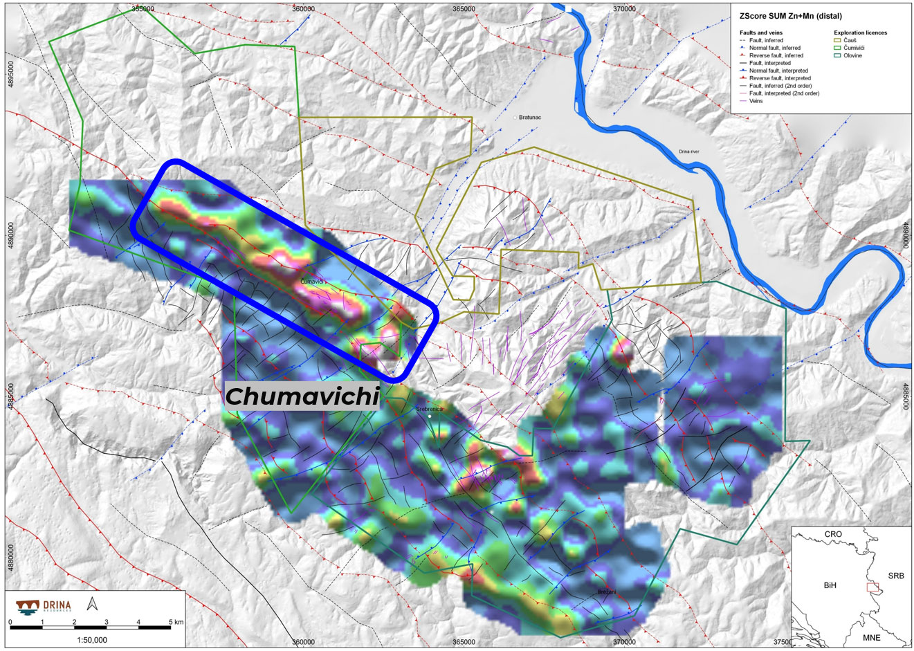
Mn+Zn Zscore SUM for soil geochemistry with elevated responses in distal environments trending NW into the Cumavici license area. Notably depleted Mn+Zn in the Olovine target area maps possible amphibole destruction in the central parts of magmatic-hydrothermal systems.
Tl+As+Sb ( distal porphyry/shallow epithermal association )
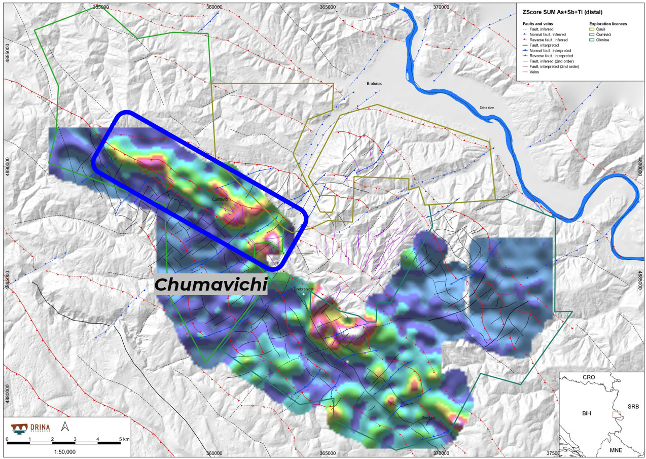
Tl+As+Sb Zscore SUM for soil geochemistry with elevated responses mapping distal or upper parts of magmatic-hydrothermal environments. Notable enrichment in these elements is observed across the known intermediate sulphidation epithermal veins of Olovine and Cumavici.
Airborne Geophysical Survey
1,350 km at 300m spacing with 150m infill @ 120m elevation conducted in May 2020
Corroborated the geochemical findings by identifying 3 prospective drill target zones.
Multiple targets with overlapping magnetic highs and conductive/resistive zones.
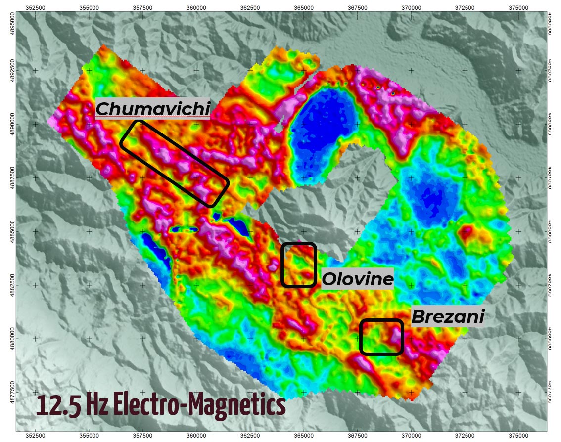
Plan section map of 12.5 Hz SkyTEM electromagnetic data.
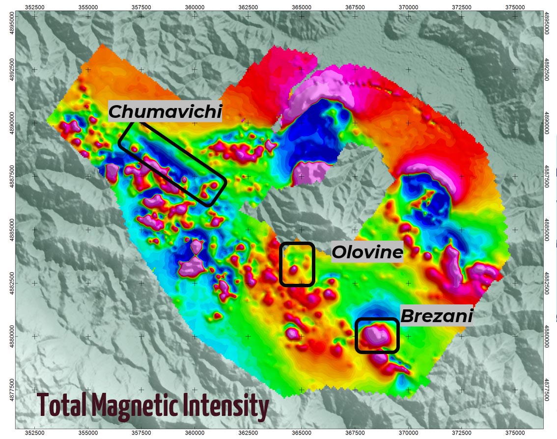
Plan map of total magnetic intensity (TMI)
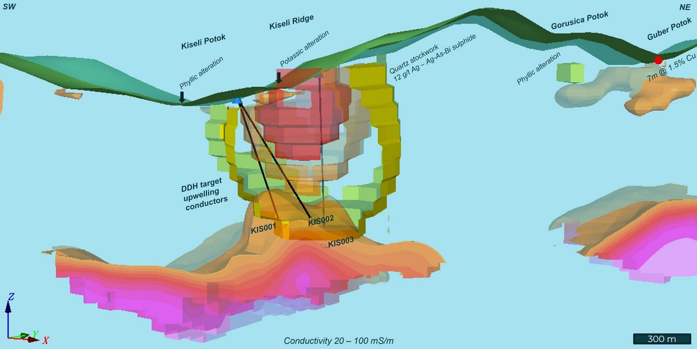
Interpretive section through the Kiseli porphyry target

Interpretive section through the Brezani target area, illustrating a large magnetic anomaly underlying Au-Bi-Te soil anomalism.
Integrated Structural Analysis
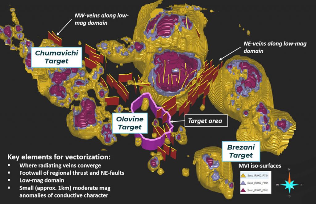
A 3D structural interpretation model using magnetic vector inversion iso-surfaces defines principal permeability corridors. The NE-SW and NW-SE structural trends which coincide with the operating Sase mine and the historically explored Chumavichi polymetallic vein zone converge at Olovine, the sector featuring the Kiseli porphyry target.
Collapse below